
Shelley & Ian’s guidebook
Sightseeing
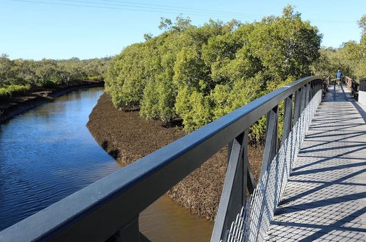
Lota Creek Boardwalk is an easy two-kilometre walking circuit, taking in a diverse array of bayside terrain including mangroves, saltmarshes and eucalypt forests.
A part of the Brisbane Bayside Parklands, the walk starts off at Whites Road, Lota, where a lovely section of well-maintained boardwalk meanders through the mangroves and across the pretty Lota Creek.
The boardwalk (and the entire circuit, for that matter) is wide enough to accommodate bikes, strollers and wheelchairs, plus those just wanting to take their time soaking in the sights.
After a few hundred metres the boardwalk makes way for a wide concrete path, which then turns into a bitumen trail. Here, the landscape changes from swampy mangroves to wide open saltmarsh flats. You’ll also pass through some paperbark and eucalypt forests as the circuit veers away from the bay.
The track is mostly flat and suited to all fitness ages, however if you do find yourself needing a break, bench seats are dotted along the way. One particular seat, perched on the banks of the creek, is a lovely spot to stop for a drink or snack.
Dogs are welcome on the circuit, provided they remain on the leash.
Nice to know – If you’re looking to make a day of it, continue 300 metres along the shared path towards Manly and you’ll find a lovely park, complete with picnic facilities, children’s playground and an enormous off-leash dog area.
Parking is available along the side of Whites Road, and the entrance to the walk is clearly marked with a large sign.
Lota Creek
Lota Creek Boardwalk is an easy two-kilometre walking circuit, taking in a diverse array of bayside terrain including mangroves, saltmarshes and eucalypt forests.
A part of the Brisbane Bayside Parklands, the walk starts off at Whites Road, Lota, where a lovely section of well-maintained boardwalk meanders through the mangroves and across the pretty Lota Creek.
The boardwalk (and the entire circuit, for that matter) is wide enough to accommodate bikes, strollers and wheelchairs, plus those just wanting to take their time soaking in the sights.
After a few hundred metres the boardwalk makes way for a wide concrete path, which then turns into a bitumen trail. Here, the landscape changes from swampy mangroves to wide open saltmarsh flats. You’ll also pass through some paperbark and eucalypt forests as the circuit veers away from the bay.
The track is mostly flat and suited to all fitness ages, however if you do find yourself needing a break, bench seats are dotted along the way. One particular seat, perched on the banks of the creek, is a lovely spot to stop for a drink or snack.
Dogs are welcome on the circuit, provided they remain on the leash.
Nice to know – If you’re looking to make a day of it, continue 300 metres along the shared path towards Manly and you’ll find a lovely park, complete with picnic facilities, children’s playground and an enormous off-leash dog area.
Parking is available along the side of Whites Road, and the entrance to the walk is clearly marked with a large sign.
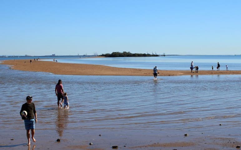
Walk out to King Island at low tide.
A definite bucket list item to experience with your Brisbane kids is the unique sea walk between King Island and Wellington Point at low tide. Although popular for its waterside playground and impressive climbing trees, visitors to Wellington Point will benefit from checking the tidal conditions first as it’s only as the waters ebb away to their lowest point that the natural sand walkway stretching between the point and King Island, situated about 1km offshore, is revealed.
The island itself, now a conservation park, is a combination of sandy pathways alongside twisted trees and surrounded by mangroves. Although uninhabited now, the island was once the home for a family for medicinal reasons in the early 1900s and plaques set up on the island tell the story of the two years they lived there in a temporary dwelling on a sand dune. A letter from Mr Philips to his sister Jo is in the possession of the Wynnum Manly historical society, depicting their life during the brief sojourn on the island.
A great experience for the whole family.
Although the island is only small, this experience is really all about the journey itself. The 2km round trip is suitable for all ages and is much loved by kids in particular as the retreating waters leave behind a pathway that is usually littered with an array of different marine life such as curling shells and small mud crabs just waiting to be discovered. Although it is important to keep an eye on the tide to make sure you don’t lose your pathway back, many people and children who are a little older like to make the trip as the path starts to dwindle – half paddling / half walking the route.
Helpful Tips for the Walk to King Island.
Here are all the things we wish we knew before walking to King Island with our kids. Timing your trip for when the low tide falls close to sunrise promises you not only a spectacular view but also a prime car spot. As Wellington Point is popular for many reasons the car parking spots during the day can fill up fast so getting there as the sun comes up means you can pretty much yell dibs to any spot you like. Of course, if you’re not up for such an early start, low tide in the afternoon is also a beautiful experience. You can check out high and low tide times for Wellington Point on the Willy Weather site. Also, as mentioned earlier, don’t leave your stay on King Island too long so that you can allow plenty of time to get back before the tide gets too high. You will see lots of other families who will begin to move back as the tide comes in, if you are anxious then just leave as others are leaving.
King Island
Walk out to King Island at low tide.
A definite bucket list item to experience with your Brisbane kids is the unique sea walk between King Island and Wellington Point at low tide. Although popular for its waterside playground and impressive climbing trees, visitors to Wellington Point will benefit from checking the tidal conditions first as it’s only as the waters ebb away to their lowest point that the natural sand walkway stretching between the point and King Island, situated about 1km offshore, is revealed.
The island itself, now a conservation park, is a combination of sandy pathways alongside twisted trees and surrounded by mangroves. Although uninhabited now, the island was once the home for a family for medicinal reasons in the early 1900s and plaques set up on the island tell the story of the two years they lived there in a temporary dwelling on a sand dune. A letter from Mr Philips to his sister Jo is in the possession of the Wynnum Manly historical society, depicting their life during the brief sojourn on the island.
A great experience for the whole family.
Although the island is only small, this experience is really all about the journey itself. The 2km round trip is suitable for all ages and is much loved by kids in particular as the retreating waters leave behind a pathway that is usually littered with an array of different marine life such as curling shells and small mud crabs just waiting to be discovered. Although it is important to keep an eye on the tide to make sure you don’t lose your pathway back, many people and children who are a little older like to make the trip as the path starts to dwindle – half paddling / half walking the route.
Helpful Tips for the Walk to King Island.
Here are all the things we wish we knew before walking to King Island with our kids. Timing your trip for when the low tide falls close to sunrise promises you not only a spectacular view but also a prime car spot. As Wellington Point is popular for many reasons the car parking spots during the day can fill up fast so getting there as the sun comes up means you can pretty much yell dibs to any spot you like. Of course, if you’re not up for such an early start, low tide in the afternoon is also a beautiful experience. You can check out high and low tide times for Wellington Point on the Willy Weather site. Also, as mentioned earlier, don’t leave your stay on King Island too long so that you can allow plenty of time to get back before the tide gets too high. You will see lots of other families who will begin to move back as the tide comes in, if you are anxious then just leave as others are leaving.
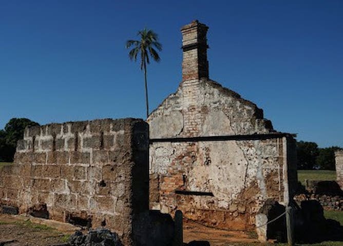
St Helena is located in Moreton Bay 5 km from the mouth of the Brisbane River and about 8km north-east of Manly. The Island has a fascinating history. Its most significant period was when it functioned as a high-security colonial prison from 1867.
The overcrowding in Brisbanes gaols resulted in the conversion of the buildings, originally intended for a quarantine station, into accommodation for prisoners. Prison labour was used for all activities on the island, from the construction of buildings and roadways to growing, processing and cooking of food.
The first few years were devoted to construction of the two cell blocks, kitchen, bakehouse, hospital, underground tanks, stables, boathouse, storehouse, jetty and Superintendents home. This formed the base of a building program which continued until the prisons last years.
In 1869, the lime kiln and sugar mill were added. Sugar cane growing and processing kept the prisoners busy until the workshops were well enough established to take over as the main source of work on the Island. These trades included bootmaking, sail-making, tailoring, saddle making, tinsmithing, candle making, book-binding and carpentry. The long termers were occupied in these workshops inside the prison stockade and the trustees engaged in animal husbandry and agriculture.
Some of the buildings were made from beachrock quarried on the island, or from bricks made on site from clay found at the northern end of the island. Others were constructed of timber imported from the mainland. Tradesmen employed as prison warders supervised this work, maintaining a high standard of workmanship and productivity. While the prison layout and organisation was based essentially on the English penal system, the prison architecture was largely a reflection of the late 19th Century trend to a colonial style of architecture.
The limited area of St Helena Island (166 hectares) and the increasing needs of the settlement, resulted in extensive clearing of the natural vegetation for agricultural and other development. The native vegetation was regarded as having little or no financial value as timber, or aesthetic value as shade or garden trees.
The Superintendent of the prison had extensive gardens surrounding his house and, for many years these gardens were considered the best in Queensland, but they consisted almost entirely of plants introduced into Australia. Crocus and White Allysum continue to thrive on the Island to this day. The Superintendent and the warders ran the prison in a highly efficient manner. For most of the prison’s 65 years; self-sufficiency was a necessity and profit was the product of that efficiency.
The St Helena Island Penal Establishment, at one stage of its operation, was considered to be the best prison of its kind in the world. The St Helena island Penal Establishment had prize Ayreshire dairy cattle that constantly won awards at the RNA show and the island’s olive groves yielded prize-winning oil at shows in Italy, the country of their origin. The entire establishment had been kept with an eye for perfection.
The life of the island rotated around the supervision of prisoners – as seen in the constant patrols, barred windows and leg irons. This constant regulation of work, behaviour and movement was the essence of 19th Century prison life. Although few people ‘swam’ in those days and shark feeding was instigated as a deterrent, escape was a constant reality. Magistrates recognised the right of each prisoner to attempt escape and the responsibility of each warder to frustrate it. Sentries were posted, windows barred and warders were constantly on the alert.
View historic timeline
The St. Helena tramway is considered to have been a most significant component of the prison establishment; it operated between 1885 and 1932 and provided the first passenger tramcar service in Queensland. Remaining evidence includes the tramway embankments, the distinguishable rights of way, the docking bay in the Stores building, the ‘Kangaroo’ car and the trolley wheels.
Administrative problems, the new social conscience, prison reform, the potential for a major fire in the aging timber buildings and the lonely isolation of warders from friends and family led to the prison’s closure in 1932. It had operated very successfully for 65 years.
Historical significance was not recognised and so, in 1925, demolition of the buildings began. This work was also done by prisoners and most re-usable materials were taken to the mainland for distribution to other Government institutions. The suggestion that St. Helena Island be made a national park was mooted as early as 1910 by the then Mayor of Brisbane. The island was the first historic site to be managed by the Department of Environment and Conservation for its historic values.
Today, approximately 7% only of the original structures remain and these are mostly the ones that were built from beachrock or brick. Restoration costs would be prohibitive so preservation of the remaining structures is the order of the day.
8 locals recommend
Saint Helena Island
St Helena is located in Moreton Bay 5 km from the mouth of the Brisbane River and about 8km north-east of Manly. The Island has a fascinating history. Its most significant period was when it functioned as a high-security colonial prison from 1867.
The overcrowding in Brisbanes gaols resulted in the conversion of the buildings, originally intended for a quarantine station, into accommodation for prisoners. Prison labour was used for all activities on the island, from the construction of buildings and roadways to growing, processing and cooking of food.
The first few years were devoted to construction of the two cell blocks, kitchen, bakehouse, hospital, underground tanks, stables, boathouse, storehouse, jetty and Superintendents home. This formed the base of a building program which continued until the prisons last years.
In 1869, the lime kiln and sugar mill were added. Sugar cane growing and processing kept the prisoners busy until the workshops were well enough established to take over as the main source of work on the Island. These trades included bootmaking, sail-making, tailoring, saddle making, tinsmithing, candle making, book-binding and carpentry. The long termers were occupied in these workshops inside the prison stockade and the trustees engaged in animal husbandry and agriculture.
Some of the buildings were made from beachrock quarried on the island, or from bricks made on site from clay found at the northern end of the island. Others were constructed of timber imported from the mainland. Tradesmen employed as prison warders supervised this work, maintaining a high standard of workmanship and productivity. While the prison layout and organisation was based essentially on the English penal system, the prison architecture was largely a reflection of the late 19th Century trend to a colonial style of architecture.
The limited area of St Helena Island (166 hectares) and the increasing needs of the settlement, resulted in extensive clearing of the natural vegetation for agricultural and other development. The native vegetation was regarded as having little or no financial value as timber, or aesthetic value as shade or garden trees.
The Superintendent of the prison had extensive gardens surrounding his house and, for many years these gardens were considered the best in Queensland, but they consisted almost entirely of plants introduced into Australia. Crocus and White Allysum continue to thrive on the Island to this day. The Superintendent and the warders ran the prison in a highly efficient manner. For most of the prison’s 65 years; self-sufficiency was a necessity and profit was the product of that efficiency.
The St Helena Island Penal Establishment, at one stage of its operation, was considered to be the best prison of its kind in the world. The St Helena island Penal Establishment had prize Ayreshire dairy cattle that constantly won awards at the RNA show and the island’s olive groves yielded prize-winning oil at shows in Italy, the country of their origin. The entire establishment had been kept with an eye for perfection.
The life of the island rotated around the supervision of prisoners – as seen in the constant patrols, barred windows and leg irons. This constant regulation of work, behaviour and movement was the essence of 19th Century prison life. Although few people ‘swam’ in those days and shark feeding was instigated as a deterrent, escape was a constant reality. Magistrates recognised the right of each prisoner to attempt escape and the responsibility of each warder to frustrate it. Sentries were posted, windows barred and warders were constantly on the alert.
View historic timeline
The St. Helena tramway is considered to have been a most significant component of the prison establishment; it operated between 1885 and 1932 and provided the first passenger tramcar service in Queensland. Remaining evidence includes the tramway embankments, the distinguishable rights of way, the docking bay in the Stores building, the ‘Kangaroo’ car and the trolley wheels.
Administrative problems, the new social conscience, prison reform, the potential for a major fire in the aging timber buildings and the lonely isolation of warders from friends and family led to the prison’s closure in 1932. It had operated very successfully for 65 years.
Historical significance was not recognised and so, in 1925, demolition of the buildings began. This work was also done by prisoners and most re-usable materials were taken to the mainland for distribution to other Government institutions. The suggestion that St. Helena Island be made a national park was mooted as early as 1910 by the then Mayor of Brisbane. The island was the first historic site to be managed by the Department of Environment and Conservation for its historic values.
Today, approximately 7% only of the original structures remain and these are mostly the ones that were built from beachrock or brick. Restoration costs would be prohibitive so preservation of the remaining structures is the order of the day.
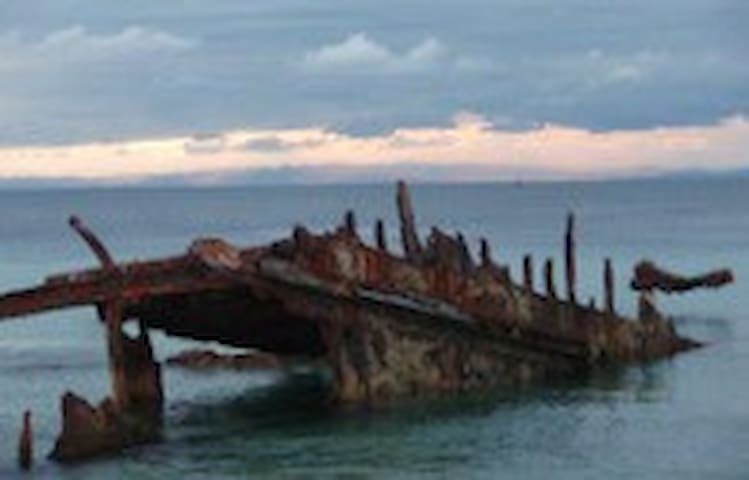
Brisbane is fortunate in having on its doorstep one of Australia's largest sand islands, making Moreton Island perfect for that much needed getaway. Moreton is almost completely sand with no roads, so a 4wd is needed if going further than walking distance from the ferry landing points. Just across the bay from civilisation, Moreton is quickly being discovered as an unspoilt paradise for people wanting to relax and enjoy nature. This is a place where the crashing of the waves sets the pace of your day.
Take the big blue watery road across Moreton Bay and come explore the beaches, starry night skies, unique adventures and accommodation of Brisbane's little Island paradise. Moreton Island delivers amazing scenery, massive sand dunes, glassy lakes, rocky outcrops, wild forest, beautiful beaches and a lonely lighthouse - you name it, Moreton Island has it!
Imagine seeing the spectacular sunset as it falls behind the Glass House Mountains while lazing about on the soft white sand beaches of Moreton. Once the sun goes down the stars come out for spectacular light show in the night sky, so clear without any city lights you could almost reach out and touch them. Then sleep under the stars in a tent, in beachfront accommodation, or at the resort, all just steps away from the crystal clear water of Moreton Bay that twinkles like diamonds in the light. Imagine no more all this is right across Moreton Bay on beautiful Moreton Island.
35 locals recommend
Moreton Island
Brisbane is fortunate in having on its doorstep one of Australia's largest sand islands, making Moreton Island perfect for that much needed getaway. Moreton is almost completely sand with no roads, so a 4wd is needed if going further than walking distance from the ferry landing points. Just across the bay from civilisation, Moreton is quickly being discovered as an unspoilt paradise for people wanting to relax and enjoy nature. This is a place where the crashing of the waves sets the pace of your day.
Take the big blue watery road across Moreton Bay and come explore the beaches, starry night skies, unique adventures and accommodation of Brisbane's little Island paradise. Moreton Island delivers amazing scenery, massive sand dunes, glassy lakes, rocky outcrops, wild forest, beautiful beaches and a lonely lighthouse - you name it, Moreton Island has it!
Imagine seeing the spectacular sunset as it falls behind the Glass House Mountains while lazing about on the soft white sand beaches of Moreton. Once the sun goes down the stars come out for spectacular light show in the night sky, so clear without any city lights you could almost reach out and touch them. Then sleep under the stars in a tent, in beachfront accommodation, or at the resort, all just steps away from the crystal clear water of Moreton Bay that twinkles like diamonds in the light. Imagine no more all this is right across Moreton Bay on beautiful Moreton Island.